By Donald Planey | October 28, 2020
Even though we are all familiar with the terms urban, suburban, and rural, there isn’t an objective definition for these terms that we can use for data analysis. However, The way we dice up geography has an impact on how we interpret the world around us. Geographical categories matter for questions about which municipality receives our property taxes, whether our insurance costs more because we live in a designated flood zone, and how our votes are weighed in the Electoral College. At Carolina Tracker, we are using the Core-Based Statistical Model, published by the U.S. Office of Management and Budget to define our geographic categories.
Interpreting space during a pandemic
Geographical categories are specifically relevant for public policy and data interpretation regarding the COVID-19 pandemic. Our access to healthcare infrastructure, social services, or employment opportunities is profoundly affected by whether we live downtown, in a major city, in a suburb, or in a low-population density rural area. Policymaking and research should be sensitive to the various impacts of the pandemic, and subsequent recession in different settings.
Geographical categories matter in research as well. Where exactly do we draw the line between rural and suburban? Or Suburban and urban? There is no objective answer, because the answer depends on what we’re hoping to measure and understand about these places. Geographic distinctions are based on our conventions, and some of these conventions work better for certain purposes than others.
Core-Based Statistical Areas
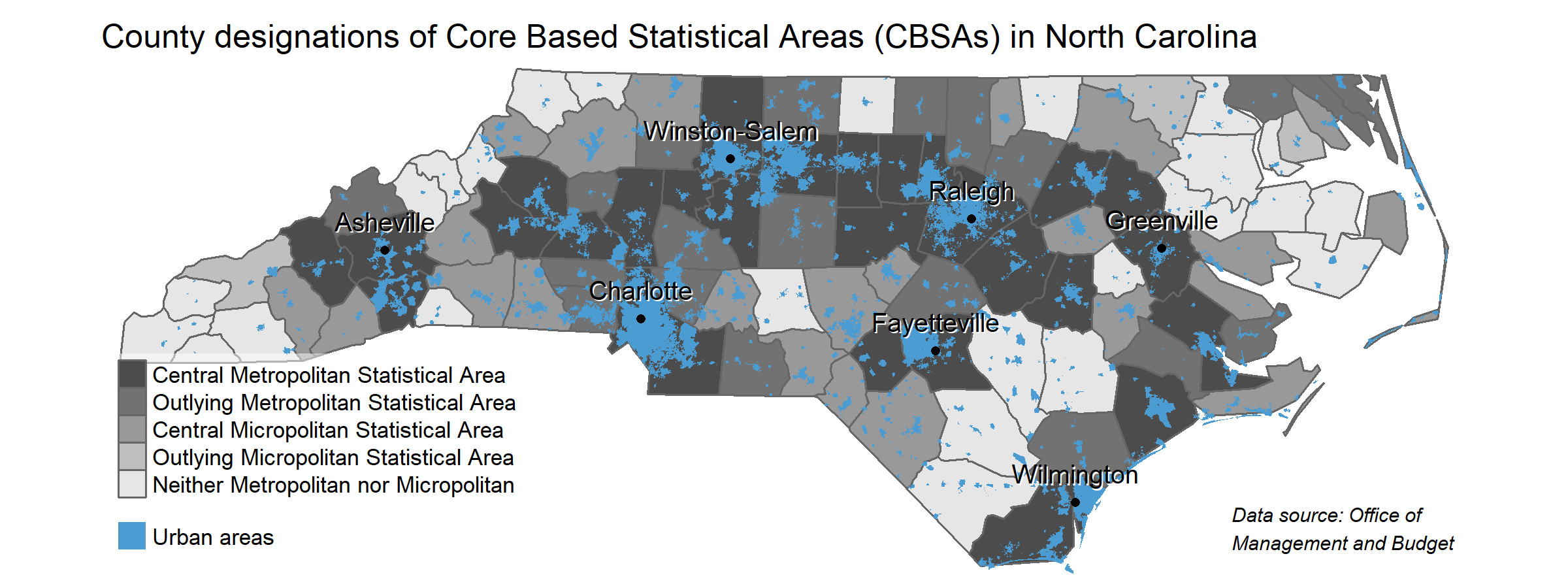
Different government agencies in the U.S. have produced different ways of categorizing what are commonly referred to as rural, suburban, and urban places. There are County Typology Codes, which classify counties by their predominant economic or industrial activities. The Natural Amenities Scale takes a different approach, drawing distinctions based on access to natural places and environmental benefits. At the Carolina Tracker, we use Core-Based Statistical Areas (CBSAs). CBSAs identify areas as either Metropolitan, Micropolitan, or neither. Metropolitan areas are regions with more than 50,000 residents, while Micropolitan areas are regions with more than 10,000 residents, but less than 50,000. Despite having smaller populations than larger metropolitan areas, they still are frequently orbited by smaller municipalities and communities. See the North Carolina Office of State Budget and Management’s list of micropolitan statistical areas in North Carolina.
Metropolitan and Micropolitan (together referred to as CBSAs) counties are composed of central and outlying counties. Central counties in a CBSA have significant portion of their population in urban areas. An outlying county is one which has significant commuting ties to the central counties in the CBSA, even when most of the population lives in non-urban areas. See Federal Register Notice 75 FR 37245 for more precise definitions.
Why not use “rural” vs. “urban”?
Imagine two rural counties with populations of 5,000 people. One is at the edge of the Charlotte metropolitan area and is classified as an outlying CBSA county. The other county also has a population of 5,000 people, but is not a part of any metropolitan or micropolitan area, making it a non-CBSA county. The outlying CBSA county at the edge of Charlotte is closer to metropolitan hospital systems, road networks, and sources of employment than the non-CBSA county. Meanwhile, the non-CBSA county is likely to have higher rates of employment in agriculture and natural resource extraction.
The term “urban” also masks significant differences. Take North Carolina’s “urban” areas, including Charlotte, a city of over 800,000 people, as well as Asheville, a city of approximately 93,000 people, or even a micropolitan area such as Lincolnton, NC. The central or outlying metropolitan or micropolitan counties of the Charlotte, Asheville, or Lincolnton CBSAs are very different places. They do not all fit one “urban” category. CBSA categories also include distinctions based on the size of a central place, which is relevant for a state such as North Carolina, whose geography is dotted with differently sized metropolitan regions.
